Atlas Mountains Map: Locations, Peaks & Regions
07 Aug, 2026
753 Views 0 Like(s)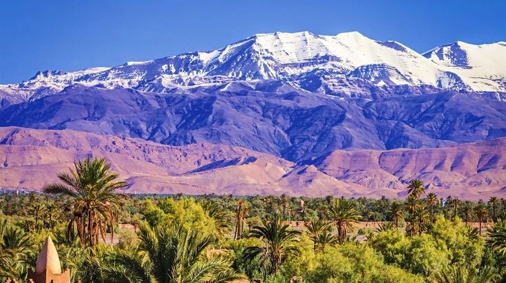
When planning a trip through Morocco, understanding the geography can make your journey much easier.
When planning a trip through Morocco, understanding the geography can make your journey much easier. The atlas mountains map is especially useful because this huge mountain system stretches across several parts of North Africa and contains different ranges, valleys, villages, and high peaks.
Morocco is home to the most famous sections of the Atlas Mountains, including the High Atlas, Middle Atlas, and Anti-Atlas. Each area has its own scenery, climate, culture, and outdoor activities. From the highest summit in North Africa to peaceful cedar forests and dry desert landscapes, the mountains offer remarkable variety.
Where Are the Atlas Mountains Located?
The Atlas Mountains map shows a mountain system extending across Morocco, Algeria, and Tunisia. However, Morocco contains some of the most spectacular and popular areas for travelers.
In Morocco, the mountain ranges generally run from the southwest toward the northeast. They create a natural geographic barrier between the Atlantic and Mediterranean regions and the Sahara Desert.
The High Atlas is the most famous section for trekking and high-altitude adventures. It passes through central Morocco and includes the country's highest mountain, Mount Toubkal.
The Middle Atlas lies farther north and is known for forests, lakes, plateaus, and traditional Berber villages. The Anti-Atlas is located farther south and has a much drier appearance, with rocky landscapes and dramatic valleys.
High Atlas Mountains
The High Atlas is the section most visitors associate with Morocco's mountain scenery. It contains many of the country's highest peaks and is a major destination for hiking, trekking, and mountaineering.
The range stretches from the Atlantic region toward the northeast. Important locations include Imlil, Ouirgane, Aït Bouguemez, and areas around Toubkal National Park.
A detailed Mountains map can help travelers understand how these destinations connect. For example, Imlil is a popular starting point for Mount Toubkal treks and is located relatively close to Marrakech.
The High Atlas also contains deep valleys and remote villages. During spring, some lower areas become green with vegetation and fruit trees, while higher elevations may remain covered with snow.
Mount Toubkal: The Highest Peak
Mount Toubkal is the highest mountain in Morocco and the highest peak in North Africa. It reaches approximately 4,167 meters above sea level.
For many travelers, Toubkal is the main reason to explore the Moroccan mountains. The standard trekking route commonly begins near Imlil and continues through mountain villages and valleys before reaching higher elevations.
The summit provides impressive views across surrounding valleys and peaks. Although the standard Toubkal trek does not require technical climbing skills under normal conditions, altitude, weather, and steep terrain should be taken seriously.
Other important High Atlas peaks include Ouanoukrim, M'Goun, and several rugged summits surrounding the major trekking routes.
Middle Atlas Region
The Middle Atlas is quite different from the High Atlas. Instead of focusing mainly on enormous rocky peaks, this region is known for forests, plateaus, waterfalls, and lakes.
Azrou and Ifrane are among the best-known destinations in the area. The region has extensive cedar forests where Barbary macaques can sometimes be spotted.
Ifrane has a noticeably different appearance from many Moroccan cities. Its cool climate, European-style architecture, and nearby forests have earned it a reputation as a popular mountain retreat.
Lake Dayet Aoua and other highland lakes provide opportunities for sightseeing and nature photography. The Middle Atlas can be particularly attractive during warmer months when visitors want to escape the heat of lower elevations.
Anti-Atlas Mountains
The Anti-Atlas is located south of the High Atlas and stretches toward the edge of the Sahara region. Its scenery is generally more arid, with rocky hills, dry valleys, and unusual geological formations.
The region around Tafraoute is particularly famous for its colorful granite formations and traditional villages. It is also an excellent destination for travelers interested in landscapes away from Morocco's busiest tourist routes.
Another notable area is the Jebel Sirwa region, which sits between the High Atlas and Anti-Atlas. This volcanic mountain area offers a different type of trekking experience.
The Atlas Mountains map is useful here because the Anti-Atlas can be overlooked when travelers focus only on Toubkal and the High Atlas.
Major Regions to Find on a Map
A useful mountain map should show more than just mountain peaks. It should also identify important towns, valleys, roads, and national parks.
Some key locations include:
· Marrakech: A major gateway for trips into the High Atlas.
· Imlil: One of the main starting points for Toubkal trekking.
· Ouarzazate: A popular base for exploring southern mountain landscapes.
· Ifrane: A mountain town associated with the Middle Atlas.
· Azrou: Known for cedar forests and mountain scenery.
· Tafraoute: An important destination in the Anti-Atlas.
· Aït Bouguemez: A scenic High Atlas valley known for traditional villages and trekking.
· Toubkal National Park: A major protected area around Mount Toubkal.
Looking at these locations together makes it easier to understand how Morocco's mountain regions are distributed.
How to Read an Atlas Mountains Map
When using an Atlas Mountains map, start by identifying the three major Moroccan ranges: High Atlas, Middle Atlas, and Anti-Atlas.
Next, look for elevation information. Maps often use contour lines or different colors to show changes in altitude. This is particularly useful when planning hiking routes because a short distance on a map can involve significant elevation gain.
Roads are another important feature. Some mountain villages are connected by paved roads, while others require travel on narrower mountain routes or walking trails.
Travelers should also check the location of national parks and protected areas. These areas may have specific rules regarding camping, hiking, wildlife, and local guides.
Best Time to Explore the Mountains
The best travel season depends on which region you want to visit.
For High Atlas trekking, spring and autumn are generally popular because temperatures are more comfortable at lower elevations. Summer can be hot in valleys, although higher elevations remain cooler.
Winter brings snow to many High Atlas peaks and can make some trekking routes more difficult. Mount Toubkal is accessible in winter for experienced hikers with suitable equipment and preparation, but conditions can change quickly.
The Middle Atlas can also become cold and snowy during winter. In contrast, the Anti-Atlas tends to have a drier climate, making some areas attractive during cooler months.
Why Maps Matter for Travelers
A good Atlas Mountains gives travelers a better understanding of distance, elevation, transportation routes, and nearby attractions.
This is particularly useful when creating a multi-day itinerary. Marrakech may be the starting point for a High Atlas adventure, but reaching remote valleys can take considerably longer than the distance appears to suggest.
Maps also help hikers understand where villages and water sources are located. In remote areas, proper planning is essential because facilities can be limited.
For photographers, maps can reveal scenic valleys, mountain passes, and viewpoints worth visiting. For trekkers, they can help identify routes that match their experience and fitness level.
Final Thoughts
Morocco's mountain regions offer far more than one famous summit. The High Atlas provides dramatic peaks and trekking routes, the Middle Atlas offers forests and lakes, while the Anti-Atlas delivers dry valleys and distinctive rock formations.
Using an Atlas Mountains map before your journey can help you choose the right destination, understand the terrain, and build a realistic travel plan. Whether your goal is climbing Mount Toubkal, exploring traditional mountain villages, photographing landscapes, or simply enjoying Morocco's natural scenery, knowing the geography will make the experience much easier to plan.


Comments
Login to Comment